Papua New Guinea map revelations never fail to amaze anyone who dives into them. Nestled in the southwestern Pacific Ocean, this vibrant nation grabs the eastern half of the world’s second-largest island, New Guinea, along with hundreds of offshore islands. It’s a place where rugged mountains kiss the sky sky, coral reefs sparkle under crystal-clear waters, and ancient cultures thrive in harmony with nature. Whether you’re planning an adventure or just curious about our planet’s hidden gems, understanding the Papua New Guinea map opens doors to one of the most biodiverse and culturally rich spots on Earth. Hey, isn’t it exciting to think about a country with over 800 languages and landscapes that shift from steaming rainforests to snowy peaks?
Where Papua New Guinea Sits on the World Stage
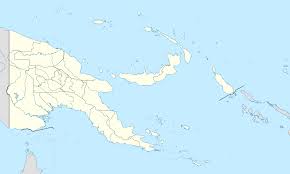
Tucked just north of Australia and east of Indonesia, Papua New Guinea occupies a prime spot in Oceania. It shares its only land border with Indonesia on the western side of New Guinea island, while maritime boundaries keep it close to the Solomon Islands and Australia. The Papua New Guinea map shows the country stretching across latitudes 0° to 12° South and longitudes 140° to 160° East, right in the heart of the tropics.
Covering about 462,840 square kilometers, it’s the third-largest island nation globally. The mainland dominates, but those 600-plus islands add a magical touch – think volcanic archipelagos and atolls dotted like jewels in the Bismarck and Solomon Seas. Port Moresby, the bustling capital, hugs the southern coast, serving as the gateway for most visitors.
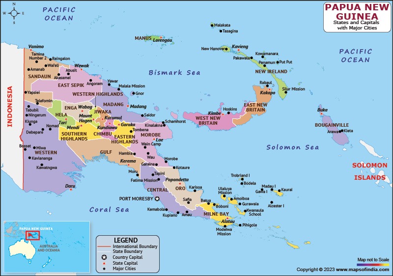
Papua New Guinea Map | HD Political Map of Papua New Guinea
Breaking Down the Papua New Guinea Map: Regions and Provinces
One of the coolest things about studying a Papua New Guinea map is seeing how the country divides into four main regions: Highlands, Islands, Momase (from Morobe, Madang, and Sepik), and Southern (also called Papuan). These aren’t just lines on paper – they shape daily life, from festivals to food.
Papua New Guinea boasts 22 province-level divisions: 20 provinces, the Autonomous Region of Bougainville, and the National Capital District. Here’s a quick table to make sense of them:
| Region | Key Provinces/ Areas | Notable Features |
| Highlands | Chimbu, Eastern Highlands, Enga, Hela, Jiwaka, Southern Highlands, Western Highlands | Towering mountains, fertile valleys, coffee plantations |
| Islands | East New Britain, Manus, New Ireland, West New Britain, Bougainville | Volcanic islands, stunning beaches, WWII history |
| Momase | East Sepik, Madang, Morobe, Sandaun (West Sepik) | Mighty Sepik River, lush rainforests, coastal ports like Lae |
| Southern | Central, Gulf, Milne Bay, Oro (Northern), Western (Fly), National Capital District | Coral seas, river deltas, Port Moresby as the hub |
This setup helps manage the country’s incredible diversity. For instance, Bougainville’s autonomy reflects its unique history and aspirations.
The Dramatic Physical Features on the Papua New Guinea Map
Oh boy, if you love dramatic scenery, the physical Papua New Guinea map will blow your mind! The mainland features a massive central spine of mountains known as the New Guinea Highlands, stretching over 1,600 kilometers. Peaks soar above 4,000 meters, with Mount Wilhelm topping out at 4,509 meters – that’s the highest in Oceania outside Australia.
Rivers like the mighty Sepik and Fly carve through the land, creating vast wetlands and floodplains. Swamps, mangroves, and pristine rainforests cover much of the terrain, while volcanoes dot the islands. Active ones, such as Rabaul on New Britain, remind everyone of the fiery forces beneath.
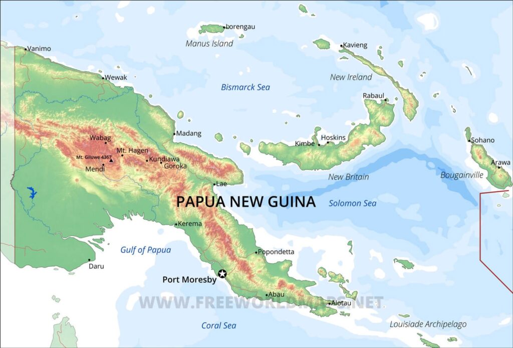
Papua New Guinea Physical Map
Rivers, Lakes, and Wetlands That Define the Landscape
Flowing across any detailed Papua New Guinea map are some of the world’s wildest rivers. The Sepik, over 1,100 kilometers long, winds like a serpent through the north, supporting unique wildlife and carved spirit houses in villages. Down south, the Fly River stretches even farther, forming a massive delta teeming with crocodiles and birds.
Lakes like Murray in the west and Chambri in the Sepik region add serene spots amid the chaos. These waterways aren’t just pretty – they’re lifelines for fishing, transport, and even gold panning in remote areas.
- Sepik River: Cultural heartland with intricate art
- Fly River: One of the least polluted major rivers globally
- Ramu and Purari Rivers: Power sources for hydroelectric dreams
The Enchanting Islands Scattered Across the Papua New Guinea Map
Zoom out on a Papua New Guinea map, and the islands steal the show. The Bismarck Archipelago, named after a famous German chancellor, includes heavyweights like New Britain and New Ireland. Volcanic and coral-fringed, they’re home to bubbling hot springs and WWII relics.
Then there’s Bougainville, with its copper-rich mountains, and the Admiralty Islands around Manus. Smaller groups like the Trobriands, known for yam festivals, or the Louisiade Archipelago, perfect for yachties, offer paradise vibes.
Climate Patterns Shaped by the Papua New Guinea Map
Thanks to its equatorial position, Papua New Guinea enjoys a tropical climate – warm, wet, and wonderful most days! Monsoons bring rain from December to March, while drier trade winds cool things from May to October. Highlands can dip chilly at night, even frosty above 2,500 meters.
This mix creates microclimates galore: steamy lowlands, temperate valleys, and alpine zones. No wonder it’s a biodiversity hotspot!
Biodiversity Hotspots Revealed on the Papua New Guinea Map
Papua New Guinea map explorations highlight why this place is a living treasure trove. Over 5% of the world’s species call it home, many found nowhere else. Birds of paradise flaunt their feathers in rainforests, while coral reefs in Milne Bay rival the Great Barrier.
- Tree kangaroos hopping in highlands
- Over 3,000 orchid species blooming wildly
- Marine life including dugongs and whale sharks
Conservation efforts are ramping up, protecting these wonders for generations.
Major Cities and Settlements on the Papua New Guinea Map
Port Moresby shines as the capital, a lively mix of modern buildings and traditional markets. Lae, the industrial powerhouse, handles shipping, while Mount Hagen thrives on coffee trade.
Other gems:
- Madang: Dive capital with clear lagoons
- Goroka: Home to colorful cultural shows
- Rabaul: Dramatic volcanic backdrop
These hubs connect remote villages to the wider world.
Why the Papua New Guinea Map Inspires Adventure and Hope
Diving deeper into any Papua New Guinea map, you’ll feel the pull of untamed beauty and resilient people. From trekking ancient trails to snorkeling vibrant reefs, opportunities abound. Challenges like remote access exist, but they’re turning into strengths with eco-tourism booming.
In the end, the Papua New Guinea map isn’t just lines and colors – it’s a promise of discovery, cultural richness, and natural splendor. Whether you’re tracing borders or dreaming of visits, this nation’s layout reminds us how diverse and optimistic our world can be.
Conclusion
Wrapping up, the Papua New Guinea map captures a country that’s truly one-of-a-kind.
First, its geography blends dramatic highs and lows, fostering incredible life forms.
Second, the provinces and regions showcase human ingenuity in a tough terrain.
Third, islands add layers of history and adventure waiting to unfold.
Fourth, rivers and climates create a canvas for sustainable growth.
Fifth, exploring the Papua New Guinea map fuels hope for preserving this paradise amid modern changes.
No matter how you look at it, the Papua New Guinea map invites everyone to celebrate a land brimming with potential and beauty. What a fantastic journey it promises!